Overview
The Gothere Maps API allows anyone to build their own programs using Gothere maps and data, whether they're on the web, the desktop or mobile devices. It's designed to make it possible for anyone to integrate Gothere Maps and services into other applications.
What are you waiting for? Read our Getting Started guide, or learn by Examples. Alternatively, if you are a kick-ass developer, dive straight into our API Reference and start coding!
NEW: Bus stops and MRT/LRT stations are now available through the GAmenities class.
Using the Javascript API
The recommended way of using the API is shown in the Getting Started example. The API is loaded using the following script tag.
<script type="text/javascript" src="http://www.gothere.sg/jsapi?sensor=false">
The sensor parameter should be set to true if the API is used together with a sensor capable of determining the user's location. The following code snippet loads the maps API and sets a function to be called when the API is loaded.
gothere.load("maps");
function initialize() {
    // Use the API with classes in the global namespace.
    var map = new GMap2(document.getElementById("map"));
    // Or score bonus points if you use classes in the gothere namespace.
    map = new gothere.maps.Map2(document.getElementById("map"));
    ...
}
gothere.setOnLoadCallback(initialize);
Using the Static Maps API
If all you require is an image of a map area, check out our Static Maps API. It's a quick and easy way to provide a simple non-interactive map on a website or mobile application. Static maps can also be used to provide graceful degradation on browsers that do not have Javascript enabled.
Developer Forum
Get help on the API at our developer forum. We'll try our best to answer all your questions.
Issue Tracker
Help us improve our API by filing bug reports and feature requests at our issue tracker.
Changelog
Visit the Gothere Maps API Changelog for our documentation on all updates to the API.
FAQ
What can I use the API for?
The world is your javascript-enabled oyster! We are almost 4 years late, but we believe the best is yet to come! Come on, let your creative juices flow and show us what you are capable of building!
How much does it cost to use the API?
Nothing. The API is provided free of charge. If you require enterprise support, drop us a note and we work something out.
Can I use the API commercially?
Yes, you can use the API commercially. However, do check our terms of service to find out what kind of services are against our terms.
Can I use the API in an intranet?
No. The API can only be used in a publicly available website or application. However, drop us a note and we can work something out.
Why is the API similar to the Google Maps API?
We believe that map APIs should be interoperable. It doesn't make sense for us to create a Gothere Maps API that locks you into using our services. By creating an API that is similar to the Google Maps API, a developer who is already using the Google Maps API will be able to switch over to the Gothere Maps API in a matter of minutes. Likewise, should our API be less than satisfactory, switching over to the Google Maps API will be a breeze.
How do I switch from using Google Maps API and vice versa?
-
Simply look for the following script tag.
<script type="text/javascript"
    src="http://maps.google.com/maps?file=api&v=2.x&key=XXXXXX">
And replace it with the following tag.
<script type="text/javascript" src="http://www.gothere.sg/maps/api/js?sensor=false">
Or if you are using the Google Ajax API Loader, look for the following script tag.
<script type="text/javascript" src="http://www.google.com/jsapi?key=XXXXXX">
Replace it with the following tag.
<script type="text/javascript" src="http://www.gothere.sg/jsapi?sensor=false">
If you are using the
google.maps.*namespace, replace all occurrences withgothere.maps.*, and you are good to go! Remember to set the sensor parameter totrueif you are using the API with a sensor capable of determining the user's location. How do I report bugs or request features?
We have an issue tracker where you can report new issues or find out more about existing ones.
Will the API change?
The Gothere Maps API is a new service, we expect it to change over time. We'll do our best to maintain backwards compatibility. To find out more about the changes between releases, you can check out our changelog.
Is my IP banned or blacklisted?
If you have gone over the usage limits, our servers may have blocked your IP address or IP address range. To curtail abuse, we may take steps to ban or block any IP address, or range of IP addresses in order to maintain the quality of service for all our users.
What are the current usage limits?
The API imposes usage limits for each IP address. We currently allow no more than 1,000 geocode requests in a 24 hour period from a single IP address. If geocode requests are submitted too quickly, we may respond with replies of status code 620. If you require a higher limit, please contact us.
I need help with the API. Where do I go?
Visit our developer forum! Post your question there and we promise we'll get back to you as soon as we can. Besides, you can look at what other developers are up to.
Do you have pretty icons I can use with your API?
-
I'm glad you asked! We have made a whole range of icons in 10 different colours. 755 icons in total for you to play with. Here's a subset of them.
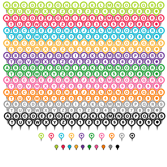
Here's a Gothere "A" marker, a medium size Gothere "A" marker, and a tiny Gothere marker. The other 9 available colors are
black,blue,green,grey,orange,pink,purple,red, andyellow. For example, here's a pink "A" marker.